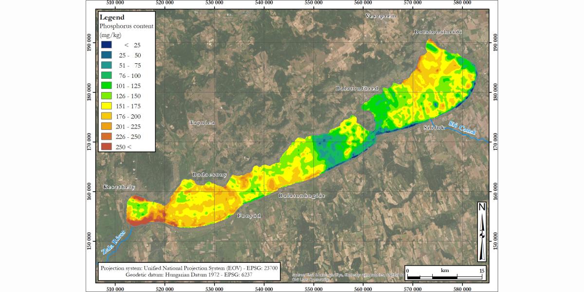
In the 1970s and 1980s, the water quality of Lake Balaton deteriorated significantly through the process of eutrophication. In the 1980s and 1990s, targeted environmental measures and a significant reduction in nutrient loads from agriculture halted the deterioration of water quality, leading to a marked improvement in the lake's environmental status from the mid-1990s. In previous years, a significant amount of phosphorus nutrients arriving in Lake Balaton settled in the bed, and was “stored” in the sediment. The favorable environmental condition lasted until the end of 2010, when the water quality of Lake Balaton deteriorated again, presumably as a result of climate change. As a result of climate change, the lake water, which is warming more and more in the summer, reveals the bound phosphorus from the sediment by catalyzing itself, thus providing nutrients for the algae, which can restart the process of eutrophication. This process has been observed in the last three years (2019, 2020 and 2021). The re-emergence of algae in the western basin of Lake Balaton (Keszthely Bay) in the middle and end of summer once again drew attention to the importance of modeling and spatially estimating the phosphorus and nitrogen nutrient load based on archival data.
We used the sediment analysis results of the Balaton research led by Professor Ferenc Máté, a former employee of our institution, for our nutrient load mapping, which was processed in a vector file in our former GIS lab in the early 2000s. In our publication in Journal of Maps, we mapped the phosphorus content of the Lake Balaton sediment with ammonium lactate extractant using various environmental (bed topography, hydrodynamic, vegetation) auxiliary variables and regression kriging. Our article published in Water is about a geostatistical method we have developed that allows the joint modeling of the phosphorus and nitrogen contents of lake sediments and the prediction of changes in their relative proportions. In the case of Lake Balaton, the results of the changes in the N:P ratio at different spatial scales and in a multivariate model support the fact that the nutrients of the water ecosystems can be estimated with high reliability based on the spatial interrelationships.